

Open Africa Routes
- Home
- Open Africa Routes
Unlocking Hidden Gems
The "Open Africa Initiative"
Discovering the Untold Stories and Treasures Beyond the City Limits
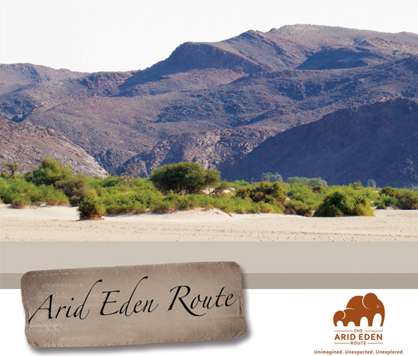
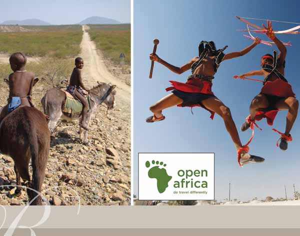
Arid Eden Route
Offering an unexpected, otherworldly experience both in its landscape and the rewards it brings to travellers, the Arid Eden Route stretches from Swakopmund in the south to the Angolan border in the north. The route includes the previously restricted western area of Etosha National Park, one of Namibia’s most important tourist destinations with almost all visitors to the country including the park in their travel plans.
The Arid Eden Route also includes well-known tourist attractions such as Spitzkoppe, Brandberg, Twyfelfontein and Epupa Falls. Travellers can experience the majesty of free-roaming animals, extreme landscapes, rich cultural heritage and breathtaking geological formations. As one of the last remaining wildernesses, the Arid Eden Route is remote yet accessible.
Total Distance: 520 km
Suggested period: 1.5 – 2 days
This national road sweeps through a well-settled farming country. The landscape includes savannah thorn veld with numerous game farms and early German settler towns with well-developed infrastructure. Novelties en route include German delicatessen, coffee shops and locally run butcheries that source delicious game and beef from surrounding farms. The excellent highway offers glimpses of families of warthogs foraging on the road verge and quick views of kudu, giraffes and other game as you pass by.
The route is a gateway to the desert attractions of this arid Eden. Towering mountain peaks, vast vistas, desert-adapted wildlife, rock art, unusual geological features and a spread of rich local cultures await the adventurous traveller. The route also gives alternate access to the much less visited, western part of Etosha National Park via the Galton Gate.
Welwitschia Experience
Total Distance: 860 km (including detours)
Suggested period: 4 – 6 days
This route links Namibia’s premier coastal holiday destination, Swakopmund with the wildlife spectacle of Etosha National Park. The well-maintained gravel road passes by some of the most spectacular landscapes and attractions in Namibia. Dominating the landscape en route are the towering Spitzkoppe and Erongo mountains. The mineral-rich nature of the area is visible when driving into Uis.
The town offers basic amenities such as fuel and other supplies, as there are no tar roads and only a handful of small towns in the region it calls for a degree of self-sufficiency.
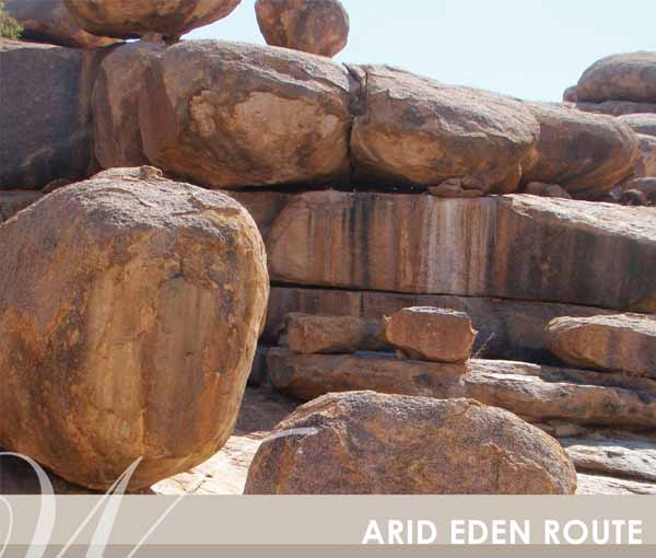
The Brandberg has at least 2,000 recorded rock art sites. The best of these can be visited on a walking tour with well-trained local guides. It is also one of the more accessible locations to view desert elephants attracted to the only greenery found in the dry riverbeds. Twyfelfontein is a prime attraction in the north-west and has a wide range of accommodations from upmarket lodges to community campsites. The World Heritage site is known to have the largest concentration of petroglyphs in Africa.
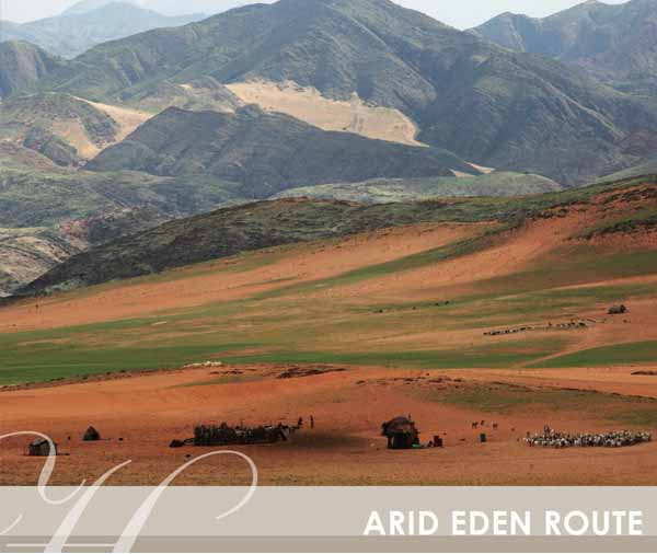
The town of Khorixas is the obvious supply point for independent travellers before heading into the more remote northern parts of this region. The simple beauty of the rocky landscape en route to Kamanjab allows glimpses of giraffes, springbok, milkbush shrubs, local villages and tribesman herding flocks of Damara sheep. Spectacular mountain passes offer endless vistas of the surrounding landscape until reaching the rural town of Kamanjab, just short of the new Galton Gate.
Himba Cultural Experience
Total Distance: 443 km
Suggested period: 3 – 5 days
This route links oasis settlements and springs through a unique part of the Himba tribal heartland. Palmwag is a cluster of ancient palm trees under which small herds of elephants congregate in the river vegetation. Local tour operators offer walking tours to find the last free-ranging black rhinos found within the conservancies.
Attractions in the vicinity include the restored German fort dating back to 1896, the promise of a refreshing swim at the spectacular Ongogo Waterfall and the Khowarib Schlucht (gorge) that offers shelter from the surrounding desert.
The stretch of road between Sesfontein and Puros skirts the sparsely vegetated Namib dune fields that support a range of wildlife such as ostriches, springbok and giraffes. The remote Himba settlement at Puros comes as a surprise in the harsh desert environment. Cool campsites under huge camelthorn trees offer shelter from the blazing sun with the odd desert elephant may stroll by. The famous Hoanib elephant herd can be tracked down by experienced local guides.
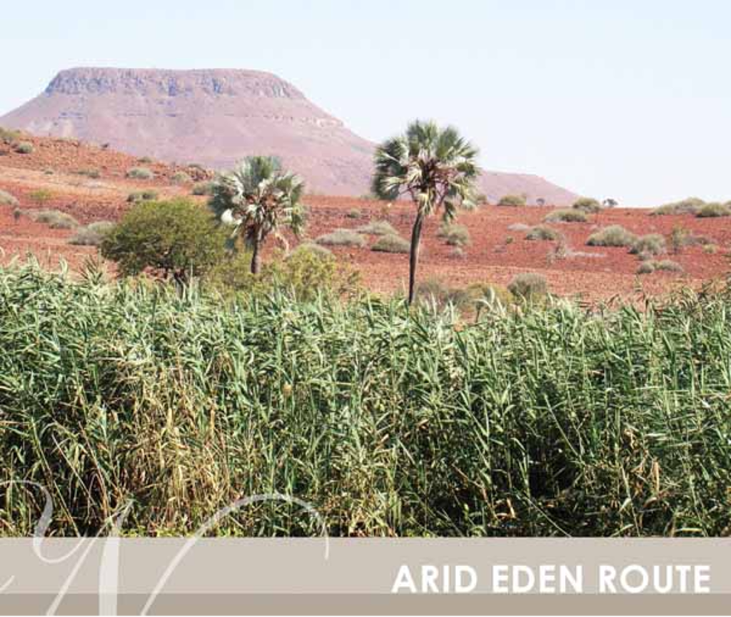
Another highlight on the route, albeit insignificant at first sight is rooidrom (red drum), a junction known by adventure travellers far and wide. This quirky landmark is a major intersection in the far north of Kaokoland and those with a sense of humour have added distance markers telling you how far you are from Moscow, London and Cape Town. The Marienfluss valley, dotted with mud-covered Himba huts, can either be covered in waving yellow grass or be a wind-sept landscape covered by a red sand. The permanently flowing Kunene River comes as a refreshing surprise with its clear water and river bank studded with Makalani palms.
North West Experience
Total Distance: 581 km (including detours)
Suggested period: 3 – 5 days
This route links up the western gate of the spectacular Etosha National Park and its teaming wildlife with another Namibian highlight the two major waterfalls on the Kunene River. The route traverses Mopani shrubland while skirting the Etosha Park fence. Opuwo, the main centre in the Himba heartland, is a necessary refuelling and supply stop.
The town is in great contrast between modern and ancient traditions. Young people in jeans and t-shirts walk the dusty roads alongside traditionally dressed Himba women covered in ochre and wearing copper bangles and leather adornment.
The good quality gravel road leads the explorer past Himba trudging the remote roads to bring their cattle, goats and donkeys to the nearest water source. The Epupa waterfall is one of the truly unspoilt natural wonders of Africa. The full force of the mighty Kunene River plunges into a narrow gorge, which sends sheets of spray into the blue Namibian sky. The river and its fast-flowing water bring life to people and animals, many of whom walk vast distances to seek replenishment, shade and shelter.
A section of the road between Swartbooisdrift and Ruacana hugs the Kunene River and offers glimpses of the river through the thick riverine forest. Keen birders hone in on a small section of the river which is home to the endemic Cinderella Waxbill. Riverfront campsites and lodges are tucked away among Makalani palms on the riverbank.
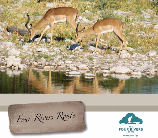
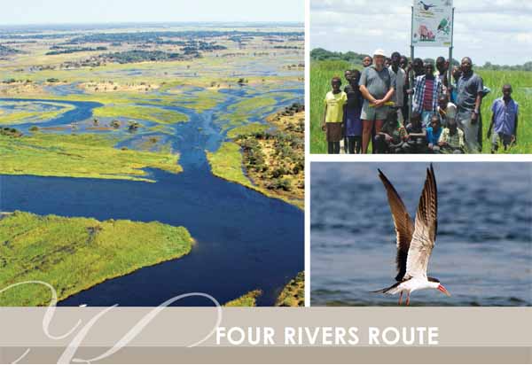
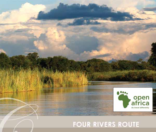
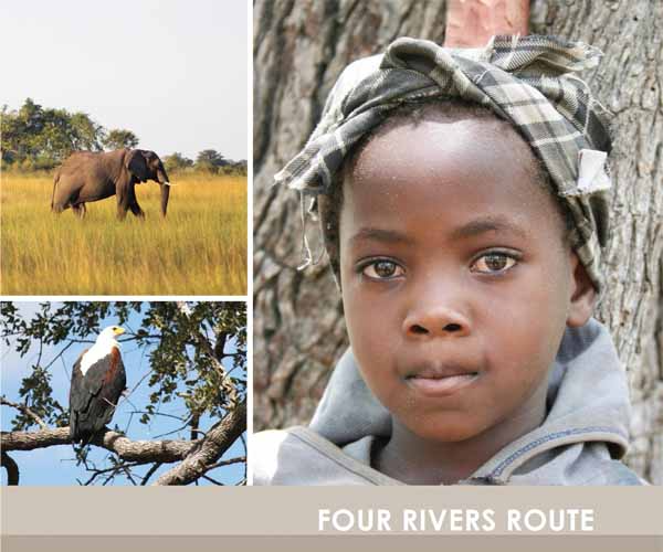
The Four Rivers – Route
With an unusual water ecosystem that gives life to rich and rare wildlife, birds and culture, the Four Rivers Route is named after the river systems that flow through the Zambezi and Kavango regions, namely the Zambezi, Okavango, Kwando and Chobe Rivers.
The unusual water ecosystem created by the rivers is one of Southern Africa’s best-kept secrets and is home to over 430 bird species, free-roaming wildlife and numerous culturally rich villages and attractions.
This route stretches from Nkurenkuru in the Northeast through the Zambezi Region (former Caprivi Strip) to one of southern Africa’s most spectacular attractions, the Victoria Waterfalls.
Kavango Open Africa Route
Total Distance: 383 km
Suggested period: 2 – 3 days
The Kavango Open Africa Route is based on the riverine landscapes of the Kavango, its people, birds and wildlife.
The route roughly stretches 383 km from Nkurunkuru in the west to Mohembo in the east and also provides access to the Mahango and Khaudum National Parks on the border of Botswana. The beauty of this area was only discovered by explorers in the late nineteenth century and is still being discovered by tourists today.
The route offers an array of attractions and a diversity of cultures and is a renowned birding hotspot. Other attractions that form part of the experience include the Mbunza Living Museum, Khaudum National Park, Nyangana Mssion, Andara Mission, the Okavango River System and Popa Falls as well as Mahango National Park.
Caprivi Wetlands Paradise Experience
Total Distance:430 km (See page 224-225)
Suggested period: 2 – 3 days
The Caprivi Wetlands Paradise epitomises the appeal of Africa with wildlife and communities living side-by-side.
The area is renowned for its successful community-based Natural Resource Management programme that allows communities specific ownership rights and allows them to protect and sustainably utilise their wildlife and other natural resources.
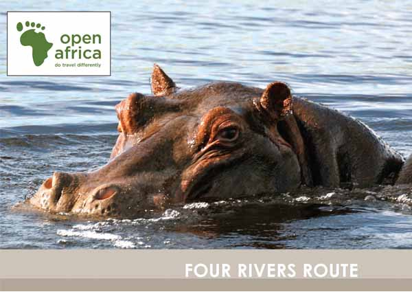
This can be seen first-hand when crossing the Okavango River into the Bwabwata National Park. Travellers will immediately realise this is not a typical park as approximately 5,000 people live in the park and derive benefits from its natural resources. It is not until you reach the Kwando River with its more densely vegetated riverine woodlands that you are likely to spot herds of elephants. The area is also known as Namibia’s birding paradise. It has varied habitats including broad-leafed and acacia woodlands, mopane forests, riverine forests, grasslands and floodplains, and therefore boasts more than 400 species of birds.
Four Corners Experience
Total Distance: 132 km
Suggested period: 1.5 – 3 days
The Four Corners Experience stretches from the Ngoma border post, through Chobe National Park in Botswana to the mighty Victoria Falls which are shared by two countries, Zambia and Zimbabwe. Along the way, travellers will have glimpses of the Zambezi River before reaching the Chobe River as it merges with the Zambezi at the confluence. Seeing the abundant wildlife of the area come to drink at sunset on the banks of the Chobe River is one of the best experiences southern Africa has to offer.
The final destination of this experience is the famous Victoria Falls, or Mosi-oa-Tunya (the smoke that thunders), Africa’s biggest spectacle of water and a sight not to be missed. Anyone with a passion for wildlife, birds and fishing will return home with a thousand pictures and a wealth of memories to share. The main attractions that form part of this experience include Chobe National Park, Victoria Falls and the Four Corners Baobab on Impalila Island.
KOAR – The Kavango Open Africa Route of Life
Named after the Region and the people who reside there, this region is home to incredible wildlife, natural beauty and an abundance of freshwater from the Okavango River.
With the Okavango River’s landscapes, people and birds, the Kavango Open Africa Route allows travellers to venture off the beaten track and explore one of Namibia’s most pristine destinations to discover what this little piece of paradise has to offer.
The Kavango Open Africa Route was developed to help attract travellers to the region to sustain livelihoods and create income among local people.
A popular attraction with those in the know, the route stretches from Katwitwi in the west to Mohembo in the east and provides access to the remote Khaudum Game Park in the South.
It’s recommended that travellers take a good few days exploring, drinking in everything it has to offer. The Kavango Open Africa Route provides an interesting self-drive route on the gravel road along the banks of the Okavango River between Rundu and Divindu.
While in Rundu be sure to visit the Khemo Open Market, which usually has a well-stocked and wide variety of famed Kavango woodcarvings while the thriving Rundu Market, which has been in existence for 20 years, is a great place to support local businesses touting everything from fresh fish and local fruits and veg to second-hand clothing, CDs and other souvenirs. The Kavango region is also a popular destination for fly fishermen due to the abundance of fish, particularly Tigerfish, African Pike and a variety of Bream species. More than 100 species of fish have been recorded so far in the Okavango River system and even if you don’t hook ‘the big one’, the river itself is enchanting and competes with all the other great African rivers as being one of the purest.
Birders will be in their element as the Kavango region is home to almost 450 bird species, such as the rarely-sighted Souza’s Shrike, Grey-headed Parrot, Rufous-bellied Tit and Sharp-tailed Starling and many more other riverine species like African Skimmer, Rock Pratincole, Slaty Egret and Carmine Bee-eater to mention a few. There are plenty of well-maintained lodges and camps along the river with activities specifically designed for bird-lovers to view these exquisite animals and birds.
Intrepid 4×4 enthusiasts can head south to the wild and unspoilt Khaudum Game Park for an experience they won’t forget. The road to the park from Katare, in the north, is extremely difficult and only experienced 4×4 travellers should attempt this. Home to some of Namibia’s most magnificent wildlife, the park is known for its predators including Lion, Cheetah, Hyena, Side-striped Jackal and the elusive Wild Dog. The remoteness of the park makes it hard to reach without a 4×4 and there are no luxury camps within the park’s confines yet. Adventurous visitors will sleep in unsecured camps next to their wild neighbours.
For the less adventurous, Mahango Game Reserve, on the border of Botswana is one of Namibia’s undiscovered gems. This pocket-sized park provides fantastic opportunities for game viewing and it is not uncommon to see over 10 different species in less than an hour. The reserve is home to a variety of wildlife including Roan, Sable, Tsesebe, Red Lechwe, Sitatunga, Elephant and many plains animals and predators.
Contact: Mark Paxton. Tel: +264 (0) 81 314 2713 Email: mw.paxton@gmail.com
Zambezi (Caprivi) Wetlands Paradise Experience
Owing to its linear shape, which gives Caprivi long international borders, the region has an interesting ethnic history with ties to neighbouring Zambia, Botswana and Angola. The Caprivi Wetlands Route takes travellers through the region which boasts three perennial rivers, making it a wetland paradise in the otherwise arid Namibia.
Caprivi links travellers closely to the world-renowned Okavango Delta and Chobe National Park of Botswana, Zambia’s and Zimbabwe’s Lake Kariba and the seventh wonder of the world, Victoria Falls (Mosi-oa-Tunya).
Day trips, transfers, camping and fishing safaris can be arranged from Namibia, and especially Caprivi, to any of these neighbouring countries. Caprivi is more tropical than the rest of Namibia, with a higher rainfall and warmer winters. Rainfall can be very variable and drought years are common. Most rain falls in summer, peaking in January and February while the hottest months for travelling through this region are from September through November. During the dry winter months, large populations of elephants and buffalo are known to congregate along the Kwando, Zambezi and Chobe river corridors, making it a great time of year for game-viewing.
The Caprivi is Namibia’s bird paradise. It has varied habitats including broad-leafed and acacia woodlands, mopane forests, riverine forests, grasslands and floodplains and therefore boasts more than 400 species of birds. The eastern floodplains and grass veld are accessible by 4×4 vehicles from May to November. There are three state-protected game reserves in Caprivi’s Wetland Paradise, namely Martini, Mudumu and Caprivi National Game Parks. Here, the limited road and infrastructural development adds a sense of adventure and wilderness. In the dry months from May to November, these parks are home to large herds of migratory buffalo and elephants.
Attractions in the wet months from December to April include bird-filled pans fringed by water lilies and inhabited by hippos. Look out for the water-loving antelope — lechwe, reedbuck and waterbuck — in the floodplains. Travellers may even see roan and sable antelope or a glimpse of the rare, semi-aquatic sitatunga found in the dense papyrus reed beds.
Omulunga Palm Route
A journey through the far north of Namibia where the desert meets the Angolan woodland and people of all cultures meet. From bustling markets with unique smells, colours and sounds to the beauty of the Etosha National Park, venture off the beaten track to discover the pulse of Namibia on the Omulunga Palm Route.
Named after the distinctive Makalani palms, known as Omulunga in the local Ovambo language, that dot the flat landscape, the Omulunga Palm Route stretches from Ruacana in the west to Nkurenkuru in the east.
It is not only the gateway to Angola but also links the remote and desolate northwest region (Arid Eden Route) to the lush water ecosystem of the Four Rivers Route (Kavango & Zambezi (old Caprivi) regions).
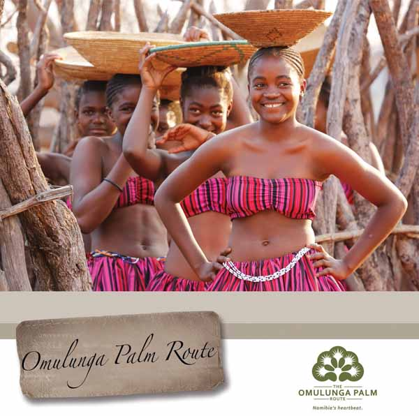
The route is the quintessential oasis for weary travellers and serves as a practical stop-over for to refuel and restock in the heart of a bustling African community. Travellers will experience traditional and contemporary Ovambo culture alongside each other and get a glimpse of local tribal royalty. The area reveals a strong liberation history, while nature lovers can enjoy the abundant wildlife and wilderness in the world-famous Etosha National Park.
Roof of Namibia Experience
Total Distance: 641 km
Suggested period: 1.5 – 3 days
The Roof of Namibia Experience links the Kunene River at Ruacana Falls with the Okavango River along the Angolan border. The route leads through numerous pans and flooded channels known as oshanas that move southward from Angola towards the Etosha salt pan. Travellers will enjoy the feeling of a rural landscape interspersed with a bustling urban landscape.
Those with a keen interest in Namibia’s recent history can enjoy attractions such as the Outapi War Museum, Ombalantu Baobab Museum and the Eenhana Shrine.
King Nehale Experience
Total Distance: 641 km
Suggested period: 2 – 4 days
The King Nehale Experience takes travellers along a journey through the colourful towns of Oshakati, Ongwediva and Ondangwa and the starkly contrasting rural villages that surround it.
Travellers will have the opportunity to visit the Omugulugwombashe National Monument, Uukwaluudhi Royal Homestead, Uukwambi Kings Monument, Oshakati Open Market, Ongula Traditional Homestead, Nakambale Museum and Lake Oponono and experience the abundant wildlife of the Etosha National Park.
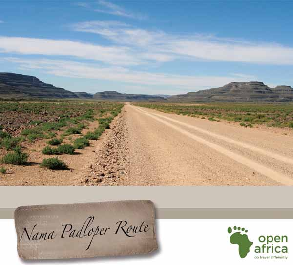
Nama Padloper Route
The Nama Padloper Route has an abundance of natural attractions with unique landscapes and a diverse range of fauna and flora. Most of the route falls within the Succulent Karoo Biome whilst the area east of the Fish River falls in the Nama Karoo Biome.
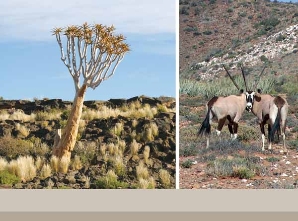
Visitors can view fauna that is unique and endemic to the area, including an isolated and near-extinct population of grey rheebok that live in the Huns Mountains; the Nama padloper tortoise and the desert mountain adder. The Springbok frog can also be spotted near seeps in the Huns Mountains.
The route is named after the Nama padloper tortoise (Ho-mopus solus), the only Padloper that is endemic to Namibia.
It grows up to 15 cm and has an orange to brown carapace, with dark pigmentation on the scute edges. The name ‘Nama’ comes from the Nama people who inhabit southern Namibia. The Nama have much in common with the San (Bushmen), sharing the same linguistic roots, light skin and small build. The term padloper is an Afrikaans word which means ‘path walker’, ‘road walker’ or ‘trail walker.’
The route starts at the Vioolsdrift/Noordoewer border post between South Africa and Namibia and follows the Orange River to the town of Rosh Pinah before heading north to the quaint village of Aus, on the edge of the Namib Desert. The road meanders along the Orange River for about 160 km before reaching Rosh Pinah. This is a truly scenic drive passing through the Aussenkehr area known for its export-quality table grapes.
You will also travel through the Aussen-kehr Nature Park and can experience the many unique features of the park by enquiring at the reception desk at Norotshama River Resort. The Ai-Ais Richtersveld Transfrontier Park opened the Sendelingsdrift point that operates across the Orange River on 17 October 2007. The trip itself takes less than five minutes, whereas the alternative route is 485 km extra to go around. A maximum of two vehicles can go across at a time, and in heavy windy weather, crossing is stopped.
Reasons To Visit:
The route provides scenic views of the river and surrounding desert mountains, synonymous with Namibia’s southern parts. The Orange River brings life to the surrounding arid lands and with the water comes a varied birdlife, like red bishops, African darters and Fish eagles.
Apart from a number of lodges and camps along the route, points of interest include the Orange River cross-ing, the abandoned Lorelei Copper Mine where some dated machinery can still be seen and the Sendelingsdrift pontoon crossing.
Rosh Pinah is a quaint town with all the basic necessities, surrounded by some of Namibia’s most attractive landscapes. Apart from being an ideal base from which to explore the surrounding areas, the village has a few of its own attractions worth noting. It has a golf and tennis club, and a number of accommodation options for tourists.
Four Deserts Route
The Four Deserts Route covers the entire southern area of Namibia, from the Orange River up to the Tropic of Capricorn. Namibia boasts four great and very different desert systems. It comes as a surprise for some that desert landscapes are not just endless stretches of sand but may be rocky and mountainous as well, at times punctuated with vast gravel plains.
In the east lie the deep, red sands of the Kalahari Desert. With a total area of 1.6 million km, it is the largest continuous stretch of sand in the world.
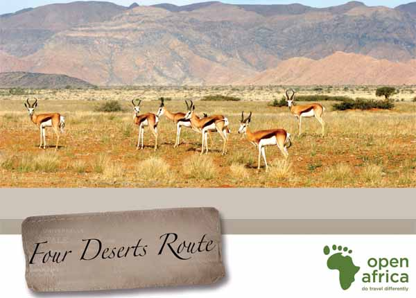
The long, parallel dunes were formed about 20,000 years ago and are partly covered with grasses, punctuated by gnarled old camelthorn trees and shepherd’s bush. The game manages to survive using special adaptations, and large herds of oryx, springbok and ostrich are once more moving across the landscape, followed by increasing numbers of vultures, marabou storks and other scavengers.
The Kalahari is the home of the San Bushmen, people who have been able to live so frugally from these resources, perfecting the art of sustainable living. The Nama Karoo covers most of southern central Namibia, driving a deep wedge northwards of the Orange River (arid South Africa) to about 120 km south of Windhoek, with a narrow strip along the edge of the Namib reaching up to Angola.
The sedimentary geological formations take on dramatic proportions in the Fish River Canyon, the second-largest canyon on Earth, formed during the break-up of Gondwanaland some 130 million years ago. Various hikes and drives afford one an opportunity to view the increasing herds of springbok, and also of oryx, kudu, mountain zebra and ostrich.
Much of the Nama Karoo consists of wide plains, broken only by the dark, enigmatic massif of Brukkaros Mountain, some 120 km north of Keetmanshoop. Perhaps it was the tranquillity of this huge desert that inspired the construction of a fairytale castle amid this landscape at Duwisib, to the west, a century ago.
Situated at Aus and extending southwards, the Succulent Karoo is mainly a winter-rainfall area. Bizarre-looking shrubs store moisture in their leaves and stems to tide them over the dry times.
The Succulent Karoo is the most plant-diverse desert in the world and has been listed as one of the world’s 25 global biodiversity ‘hotspots’. Although these floral wonders are at their best after the rains, they are well worth investigating throughout the year. Luderitz provides a fascinating breakaway, its harsh, minimalistic landscape resembling that of an island.
In the vicinity one can hear and see African penguins as they go about their activities, and on a visit to the ghost diamond mining town of Kolmanskop one wonders about the lives of the past inhabitants of this desert settlement.
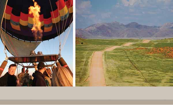
To the north, the Namib Desert lies in a narrow strip along the Atlantic Ocean. The scenery ranges from shift-ing, glowing red dunes in the south to gravel plains with inselbergs in the central parts, and jagged blue mountains in the north and east, with deep valleys cut by ephemeral rivers. Fog supplies the life-giving moisture for plants and animals.
Here, visitors have a wide range of experiences to choose from: clambering up some of the highest sand dunes in the world at Sossusvlei at dawn; discovering the ancient, fossilised red dunes south of Solitaire as they stand frozen in time; gazing at huge black lappetfaced vultures as they arch across the sky; or following in the tracks of a solitary oryx across the gravel plains. One of the ultimate ways of experiencing this desert is to drift by balloon over the endless red dunes in the early morning sun.
Unveiling Southern Africa's Hidden Charms
Open Africa is a social enterprise that helps people see what is unique and valuable in places outside of the city. It opens people’s eyes to what is special about these places and reveals the people and the stories that make their country a life-enriching place.
Experiencing the world in new ways excites and revitalises people. Sometimes people need a new perspective to discover things they didn’t notice before. Open Africa knows that tourism helps rural communities grow.
Open Africa has 2,500 destinations in Southern Africa, and they have visited every single one. They know the hosts. They have tasted the homemade bread and swung through the treetops on the zip line. They help hosts create unique Open Africa experiences so that visitors can feel confident about discovering new places, new things and new experiences.
Whether they are an adventure seeker looking for exciting and different places to explore, or a family looking for a special place to gather, Open Africa connects people to eye-opening places and experiences.
When people feel part of something bigger than themselves and can understand each other easily and openly, they can work together to enrich their lives.
Today Open Africa works with 2,500 entrepreneurs across Southern Africa, helping them feel proud of what they have and helping them discover and share their value so that they can attract people to their region.