

Gateway to Namibia: Border Entry Points Explore the Entryways to Namibia from Its Neighbouring Countries Namibia | Angola Summer Winter Phone Ruacana 08:00 – 19:00 07:00 – 18:00 065 270 290 Omahenene 08:00 – 19:00 07:00 – 18:00 065 295 504 Oshikango 08:00 – 19:00 07:00 – 18:00 065 264 615 Katitwe 06:00 – 18:00 06:00 – 18:00 066 255 356 Rundu 06:00 – 18:00 06:00 – 18:00 066 255 356 Namibia | Zambia Summer Winter Phone Wanela (Katima Mulilo) 06:00 – 18:00 06:00 – 18:00 066 253 430 Namibia | Botswana Summer Winter Phone Ngoma 06:00 – 18:00 06:00 – 18:00 066 252 856 Muhembo 06:00 – 18:00 06:00 – 18:00 066 259 900 Dobe (Tsumkwe) 06:00 – 18:00 06:00 – 18:00 067 243 328 Buitepos | Mamuno 07:00 – 24:00 06:00 – 23:00 062 560 404 Namibia | South Africa Summer Winter Phone Velverdiend / Mata Mata 08:00 – 16:30 07:00 – 15:30 063 222 114 Klein Manasse / Rietfontein 08:00 – 16:30 07:00 – 15:30 063 280 681 Ariamswviei / Nakop 24 hours 24 hours 063 280 057 Velloorsdrif / Onseepkans 08:00 – 16:30 07:00 – 15:30 063 269 134 Noordoewer / Vioolsdrif 24 hours 24 hours 063 297 122 Sendelingsdrif 07:00 – 24:00 06:00 – 23:00 063 222 114 Oranjemund 06:00 – 22:00 07:00 – 23:00 063 232 756
Read More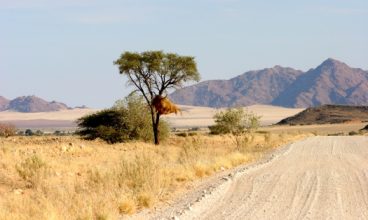
Navigate Namibia: Distance Chart Plan Your Journey with Comprehensive Distances Between Key Destinations
Read More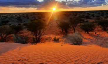
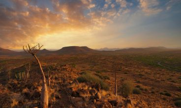
Exploring Namibia’s Eastern Region East – Kalahari Desert Kalahari conjures up visions of ancient red dunes, Lourens van der Post, the Bushmen (San) and black-maned lions. It is very different to the Nam ib, as it is not a desert in the strict sense of the word.On average, it receives more rain than a true desert, well over 100 millimetres a year, in some areas as much as 250 millimetres. However, the sand sheet that covers the Kalahari has virtually no surface water. Evidence suggests that the region once may have been much more arid than it is now. A better description of the Kalahari would therefore be that it is a ‘fossil desert’ rather than a true desert. The word ‘Kalahari’, meaning ‘a waterless place’, is derived from the Tswana word Kgala, meaning the great thirst, or the tribal word Khalagari, Kgalagadi or Kalagare. Vast areas of the Kalahari are covered by red sand, accumulated in longitudinal or linear dunes that trend parallel to the prevailing wind. They are generally straight and very long, with sharp crests. Formed many centuries ago, they have become fixed by vegetation of the acacia type and grass cover, with broad dune ‘streets’ in between. An outstanding feature of the Kalahari dunes is their extraordinary red colour, which is due to a thin film of red iron oxide that coats each grain of sand. Summer temperatures in the Kalahari range from 20-45°C. When it rains the water drains away into the dry dune valleys. Still, the region has several seasonally inundated pans, such as the Etosha Pan in northern Namibia and the large salt pans of the Makgadikgadi Pan in Botswana. Animals that live in the Kalahari include lion, brown hyaena, meer-kat, giraffe, warthog, jackal, eland, gemsbok, springbok, hartebeest, steenbok, kudu and duiker, and many species of bird and reptiles. Vegetation in the Kalahari consists mainly of grasses and acacias, but there are over 400 identified plant species present, including the wild watermelon or tsamma melon. The Sari people or Bushmen have lived in the Kalahari for some 20,000 years as hunter-gatherers, surviving by hunting game with bows and arrows and gathering edible plants such as berries, melons nuts and also insects. Bushmen rarely drink water, getting most of their water requirements from plant roots and desert melons found on or under the desert floor, and storing water in blown-out ostrich eggshells. They have their characteristic language that includes clicking sounds. There are several excellent guest farms and lodges in the Kalahari, including the well-known flying centre at Bit-terrasse, a major attraction for gliding, also referred to as ‘soaring’. Most of these establishments include visits to the Bushmen, who tell tourists about their lifestyles, including how they track and hunt, which plants they incorporate into their diet and the many medicinal uses of plants.
Read More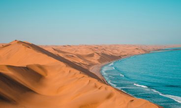
Exploring Namibia’s Western Region The Western Region is centred around the Namib Coastline, which offers a welcome respite from the heat of the interior. The quaint little town of Swakopmund is Namibia’s premier holiday resort with its wealth of well-preserved German colonial buildings, its palm-lined streets, and clean beaches. Activities abound in and around Swakopmund. From dune boarding to sky-diving and ballooning over the desert, township tours, and tours into the desert, there is much to do and see in this area. Walvis Bay is Namibia’s major port and the center of Namibia’s fishing industry. Most boating activities are launched from Walvis Bay’s waterfront which has become a big tourist attraction. The calm waters of the lagoon attract many watersport enthusiasts like windsurfers, kiteboarders, and sailors. Pelican Point is also known for its rough beauty, and the newly built eco-lodge at the tip of the peninsula offers comfort and a rather different view of the lagoon and Walvis Bay as a whole. Donkey Bay is a well-known surfing spot for international surfers from all over the world who come here to share the icy waters with the hundreds of seals around the lighthouse. Many 4×4 excursions to Sandwich Harbour start out in Walvis Bay. Sandwich Harbour lies about 40 km south of Walvis Bay with dunes sweeping down to a pristine lagoon with views and scenery to die for — a photographer’s dream. But if it is just fishing that tickles your fancy, the coastline to the north of Swakopmund and Henties Bay offers exciting spots with amusing names such as “Sarah se Gat” and “Bennie se Rooi Lorry”, or Jakkalsputz. From Mile 4 and Wlotzka’s Baken right up to Henties Bay, Torra and Terrace Bay, you’ll find many fishing spots, directly accessible by 4×4 which makes fishing a family affair with camps being built on the beach and family and friends gathering for a fun-filled day on the beach. Further inland, the Brandberg offers the highest peak in Namibia: Koenigstein (2570 m above sea level). In addition, it offers 44,000 rock paintings, the most popular of which is the White Lady in the Tsisab Ravine. The Erongo mountains to the south-west of Omaruru also contain a wealth of rock paintings and the town of Omaruru itself has become somewhat of an art centre, featuring many coffee shops, art and decor, as well as its own chocolate/praline factory. The Spitzkoppe is considered the “Matterhorn of Namibia” and with its granite rock walls of up to 600m, it is Namibia’s top rock climbing destination. Many lodges and guestfarms in and around these tourist attractions have exciting game viewing possibilities of all types of game including the big 5. Places of Interest in the Western Region: Swakopmund When you approach Swakopmund on the tar-red road from the interior, its quaint assemblage of towers and turrets rise mysteriously from the mist, creating a mirage of an ancient city in a faraway land. These atmospheric conditions are generated by the dense bank of coastal fog that hangs over the cold Atlantic Ocean on most mornings, dissipating as the sun rises higher in the sky. Sometimes the sea is a sleek silver mirror; other times it is grey and stormy, with waves breaking onto the shore in rollers of thick white froth. Germany’s annexation of the territory of Deutsch-Sudwestafrika became reality in August 1884 when the German flag and wooden notice boards were planted at various points along the south-west African coast, proclaiming the protection of the Reich, and supplanting, after 400 years, Portugal’s claims to sovereignty over the territory. There was only one viable natural harbour along the coast, namely Walvis Bay, but it was still in British hands. The new German colony’s need for a port of its own led to the founding of Swakopmund in 1892, and it served as the territory’s main harbour for many years. Today the coastal town is Namibia’s main seaside resort, and locals descend on it from the interior in large numbers to escape the heat of the summer (December/ January). The town has a cool and bracing climate, and its large number of restaurants carefully tended public gardens, a wide choice of pensions and hotels, and coffee shops selling traditional German cakes and pastries make it an enjoyable holiday destination. Many of the old colonial buildings with their distinct German architecture have been preserved, such as Woermann House, built in 1905, which houses the Swakopmund Arts Association and the Public Library; Die Alte Kaserne (1905), today a youth hostel based on the concept of the International Youth Hostel Federation; the privately owned Hohenzollern-Haus (1905); and the Prinzessin Rupprecht Heim, built-in 1902 as a hospital, today serving as a pension. The Old Iron Jetty, originally built in 1911, is a well-known landmark that was closed for repairs for many years and was re-opened to the public in 2006. The Swakopmund Museum is a small but comprehensive institution with displays ranging from natural history, botany, and mineralogy to ethnological and historical displays. On the beachfront is the Swakopmund Aquarium, a favourite among children with its transparent oval-shaped tank and glass walk-through tunnel. An interesting shop to visit is the KristalI Galerie with its specialist mineral displays, including gigantic quartz crystal clusters. A visit to Swakopmund would not be complete without enjoying coffee and cake at Cafe Anton, famous for delectable classics such as Schwarz-Walder Kirschtorte, Florentiner, and Apfelstrudel. Welwitschia Plains Inland from Swakopmund, like huge bundles of tangled wool, the ancient Welwitschias of the central Namib sprawl randomly across the well-known Welwitschia Plains in the Namib-Naukluft Park. This intriguing stand of plants can be viewed when traveling through the proclaimed road in the northern section of the park. The Welwitschia mirabilis is a botanical curiosity endemic to the Namib Desert. The plants grow in a narrow belt that lies between 30 to 40 kilometers inland, from the Kuiseb River in central Namib more or less up to Mossamedes in Angola. The best specimens grow amongst the hills
Read More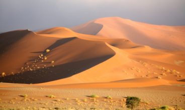
Exploring Namibia’s Southern Region The south of Namibia is dry – a land of wide-open spaces and solitude, bordered in the west by the Atlantic Ocean as well as the spectacular Namib Naukluft Park. This area is worth one entire trip on its own, as it offers so many unique attractions and phenomena, ranging from ghost towns to historical buildings, quiver tree forests and canyons, not to forget the dunes which are considered among the highest in the world. The town of Lüderitz was built amongst rocky outcrops on the southern Namibian coast and owes its existence to the discovery of diamonds in 1908. It has become a sought-after tourist attraction and holiday resort with its German colonial buildings, the mining ghost towns of Kolmanskop, Elizabeth Bay and Pomona, which seemed to have survived time and the elements. The Sossusvlei clay pan, which was formed when shifting sand dunes of the Namib smothered the course of the Tsauchab River, is one of the main attractions of the southern region. The dunes are at their most breathtaking in the early morning and their formations and colour variations are a scenic haven for photographers. The rugged Naukluft mountains are home to many Hartmann’s mountain zebra, as well as klipspringer, gemsbok, ostrich, springbok and kudu. This area offers various hiking trails, either on foot or by 4×4. Sesriem is a 30 m deep canyon or gorge of about 1 km in length which lies at the entrance to Sossusvlei. Its rock pools fill up with water after good rains and serve as wonderful, refreshing dip pools for hikers. The spectacular Fish River Canyon is one of the largest canyons in the world, reaching a depth of about 550 m. The adjoining Ai-Ais National Park and Richtersveld National Park on the South African side have been designated a transfrontier conservation area, separated by the Orange River which forms the natural boundary between the two countries. Around Keetmanshoop a forest of quiver trees has pride of place and just north of Mariental the Hardap Dam, which is Namibia’s largest dam, offers a resort and water sports such as water skiing, body boarding and the like. Places of Interest in the Southern Region: Fish River Canyon The longest river in Namibia, the Fish, flows for more than 800 kilometres from its source in the Naukluft Mountains to its confluence with the Orange River, 110 kilometres east of the Atlantic Ocean. Over millennia it has carved one of the world’s greatest canyons, a 550-metre-deep chasm that twists for 160 kilometres through eroded cliffs of ancient sandstone, shale and lava deposited almost two billion years ago. Quiver trees and euphorbia species dot the arid desert plain through which the canyon flows. Except in extremely dry years, there is always water in some of the pools, due to the intermittent flow of the river. They contain small- and largemouth yellowfish, sharptooth catfish, tilapia and common carp, and sometimes water leguan. Klipspringer, rock hyrax, ground squirrel and baboon inhabit the cliffs and niches of the canyon walls, while tracks at the waterholes bear witness to the leopard and mountain zebra that also frequent the area. Many birds are found here, including the olive thrush, Cape robin and African black duck. Centrepiece of the Fish River Canyon is an 85-kilometre nature trail regarded as one of Southern Africa’s major hiking challenges. In terms of difficulty, the trail is compared to the daunting Otter Trail in South Africa and ranks among the Big Five hiking trails in the Southern African region. Hemmed in by sheer canyon walls towering above the meandering river, the trail takes four to five days to hike, starting at the northernmost viewpoint close to the Hobas campsite. Chain handholds are provided to descend to the canyon floor. At the bottom is an enormous pool where hikers can cool off before continuing further, determining their own pace and choosing where they want to set up camp. Along the way, they can enjoy rugged scenery, peace, solitude and total wilderness. The trail ends at the Ai-Ais Hot Springs Resort, where hikers can relax in the soothing thermal waters of the hot-water spring. The hike can be undertaken only from 15 April to 15 September, due to high summer temperatures and the danger of flash floods during the rainy season. Quiver Tree Forest Few iconic images beat the quiver tree or kokerboom, Aloe dichotoma, its stylised shape giving it a prehistoric appearance, especially when etched against the deep colours of a Namibian sunset. Situated on the farm Gariganus, 23 kilometres northeast of Keetmanshoop, the Quiver Tree Forest is a worthwhile de-tour, especially for keen photographers. Here several hundred of these curious trees can be seen growing as a dense stand amongst the rocky outcrops that are so characteristic of the southern parts of Namibia. The stand was declared a national monument and fenced for tourist viewing some fifty years ago. Reaching heights of up to seven metres, the quiver tree is one of four Namibian aloes that are classified as trees. One of these, the bastard quiver tree, Aloe piIIansi, is sometimes confused with the kokerboom, the difference being that A. piIlansi has a taller trunk with fewer, more erect branches and a sparse crown, and has a much more limited distribution, being confined to the areas just north and south of the Orange River. The quiver tree, on the other hand, grows fairly commonly along Namibia’s western escarpment from the Orange River northwards into Kaokoland. In June and July, quiver trees are covered in bright yellow flowers, attracting large numbers of birds and arid insects to their copious nectar. Baboons tear the flowers apart to get at the sweet substance, often stripping a tree of its blossoms soon after they have appeared. One of the quiver tree’s most attractive features is its bark, which is smooth, often with a pearly grey or golden sheen, sometimes flak-ing and cracked into diamond shapes, frequently folding like melting wax. The Governor of
Read More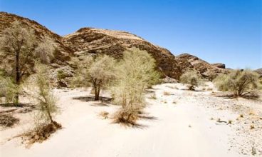
Exploring Namibia’s North Western Region The north-west of Namibia, also named the Kunene region, stretches from the Kunene River in the north right down to the Ugab River near Twyfelfontein. It is a rugged terrain with rock-strewn hillsides, rugged mountains and sandy plains. It is advisable to explore this wild and isolated region in a four-wheel drive, since most destinations are off-the-beaten-track, especially along the Kunene, with its splendid Epupa Falls. Kaokoland is the ancestral homeland of the nomadic Himba tribe. The Himba are tall, slender and photogenic people of Herero origin. Especially women are admired for their unusual sculptural features, their intricate hairstyles and traditional adornments. Furthermore, the Kaokoland is home to the famous “Desert Elephants” that migrate along river valleys in search of water and food. Further down, to the west of Khorixas lies Twyfelfontein (meaning “doubtful mountain”), with its open-air art gallery of 2400 rock engravings which has World Heritage Status since 2007. Close by are also the Petrified Forest, the Burnt Mountain as well as the famous Organ Pipes, a series of angular dolerite columns exposed in a dry riverbed. Furthermore, this area offers more geological phenomena such as the 80 km long Ugab terraces, as well as the Vingerklip, a 35m high monolith which towers over the Ugab valley. Places of Interest in the North Western Region: Twyfelfontein In 2007 the Twyfelfontein rock-engraving site in the Huab Valley west of Khorixas was awarded World Heritage status at a meeting of the World Heritage Committee in Christchurch, New Zealand. The 2,000-plus rock engravings represent one of Africa’s largest and most important rock art concentrations. Here great Etjo sandstone formations provided the can-vases used by the rock artists who created the gigantic open-air gallery some 2 000 to 6 000 years ago. Many stone artefacts, tools, ostrich eggshell beads and pottery typical of hunter-gatherers of the past 10,000 years have been excavated at Twyfelfontein, an Afrikaans word that means ‘doubtful fountain’. Many stone artefacts, tools, ostrich eggshell beads and pottery typical of hunter-gatherers of the past 10,000 years have been excavated at Twyfelfontein, an Afrikaans word that means ‘doubtful fountain’. The engravings mostly depict animals and geometric designs, although human figures are sometimes portrayed in the newer ones. An interesting aspect of the rock engravings is that many depict animals as seen in a trans or supernatural state, while the abstract and geometric patterns are entopic images, patterns or flashes seen through the eyes of the shaman as he enters the state of trance and the spiritual world. The supernatural creature would often take on the appearance of a familiar animal like a giraffe, elephant or lion with special powers to heal the sick or bring rain rather than being depicted because the animal is abundant in the area. The sites of the specific engravings were likely chosen deliberately at significant points in the rocks. Some are in cracks and fissures, which may have served as doorways to the supernatural world, while others may have been engraved in areas to concentrate the energy for a journey into the spiritual world. The engravings are believed to have been produced in the dry season when the shortage of water made people congregate near the spring. The Visitors’ Interpretive Rock Art Centre at Twyfelfontein is an innovative building with an architectural design based on the three stages of trance, providing visitors with a comprehensive background of the rock engravings and the origin of the site. There are several good lodges in the surroundings, and many interesting geological and other features to view. Skeleton Coast Renowned for its extraordinary scenic beauty, the Skeleton Coast remains one of Namibia’s most enduring and mysterious places. Its attraction lies essentially in the colour, vastness, changing moods and untouched quality of its landscape. Once an area for seafarers to fear and shun because of its treacherous coastline flanked by bone-strewn desert wastes, today it is prized as a place of splendour and tranquillity. Situated in the remote north-western corner of Namibia, the Skeleton Coast Park is a narrow tract of coastal desert about 40 to 50 kilometres wide and 500 kilometres long. Extending between the Ugab River in the south and the Kunene River in the north, it was proclaimed a nature reserve in 1971. Because of its ecological sensitivity, the nature conservation authorities manage it as a wilderness area insofar as the development of infrastructure is kept to a minimum and the number of visitors is restricted, with facilities and accommodation kept simple and basic. It has accordingly become a haven for discerning visitors interested in the specific qualities of the area. The skeletons scattered along this inhospitable coastline are not only those of hapless sailors whose vessels came to grief on the rocks. The bleached bones of countless whales, exploited in the heyday of the whaling fleets, and the sand and wind-blasted remains of tugs, liners and trawlers lie strewn untidily for endless miles of desolate beach. At the river mouths, lying in tangled heaps, are the skeletons of a myriad trees, washed down from the interior in good rain years. The landscape varies from vast desert plains often coloured green when the coastal fog has brought the lichen fields to life; sweeping vistas of windswept dunes, their ivory-white backs often coated maroon with fine garnet sand, or black with magnetite and ilmenite; rugged canyons with walls of richly coloured volcanic rock; and extensive variety of animals and birds are found in the remote desert realm. On the plains are jackal, gemsbok, springbok, brown hyaena and ostrich, while lion, giraffe and desert-adapted elephant and black rhino roam up and down the dry river courses, in effect linear oases with vegetation and the occasional spring-fed waterhole. The northern section of the park is a tourism concession area and is restricted to fly-in safaris only. The southern section between the Ugab and Hoanib rivers is accessible to the general public, who can stay at the Terrace Bay resort or camp at Torra Bay,
Read More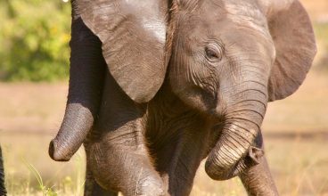
Exploring Namibia’s North Eastern Region The northeastern region of Namibia stretches from the Kavango region right through to the end of the Caprivi (Zambezi) strip. This region is typically African, with scattered rural settlements, lush tropical vegetation, expansive floodplains and an abundance of birds and game. Near Tsumkwe, the Nyae-Nyae area represents the homeland of the Bushman/San people. This area was formerly known as Eastern Bushmanland and is a little off the beaten track, thus a 4×4 vehicle is advisable. Similarly, the Khaudum National Park, which lies further north of Tsumkwe, is also only accessible by four-wheel drive. The Baobab tree is a distinctive species found in this area, recognizable by the enormous diameter of its trunk. The main town of the Kavango region is Rundu which is situated on the banks of the Okavango River. This region is particularly known for its woodcarvers. This ancient craft has been handed down over generations and is a flourishing industry. When heading further eastwards, the Caprivi Game Park extends into the Mudumu and Mamili National Parks. Herds of elephants are particularly abundant in this area and are best observed around the Chobe and Kwando rivers when they come down for their drink before sundown. Katima Mulilo is the main town of the Caprivi region and is considered the gateway to Victoria Falls in Zimbabwe/Zambia and the Chobe National Park in Botswana. North-East is well known for its fishing (especially the sought-after Tiger Fish), game viewing and bird watching (over 400 bird species are found in this area). Places of Interest in the North Eastern Region: The Kavango Named after the people who reside there, Namibia’s Kavango region is home to incredible wildlife, natural beauty and an abundance of freshwater from the Okavango River. The Kavango region is also a popular destination for fly fishermen due to the abundance of fish, particularly Tiger fish, Bream and African pike. More than 150 species of fish have been recorded so far in the Kavango River and even if you don’t hook the big one, the river itself is enchanting and competes with all the other great African rivers. Locals travel up and down the river on ‘mokoros’, typical dugout canoes used in the Kavango region that are made from hollowed-out tree trunks. Birders will be in their element as the Kavango region is home to more than 400 species of bird, such as the rarely-sighted Souza’s Shrike, Grey-headed Parrot and Sharp-tailed Starling amongst many other species like African Skimmer and Carmine Bee-eater. There are plenty of well-maintained lodges along the river with hides erected specifically for bird lovers to view these exquisite animals around waterholes. Intrepid 4×4 enthusiasts can head south to the wild and unspoilt Khaudum Game Park for an experience they won’t soon forget. The road to the park from Katare, in the north, is extremely difficult and only experienced 4×4 travellers should attempt this. Home to some of Namibia’s most magnificent wildlife, the park is known for its predators including lion, cheetah, hyena and the elusive wild dog. The remoteness of the park means it’s hard to reach without a 4×4 and as there are no luxury camps within the park’s confines, brave visitors will sleep in unsecured camps next to their wild African neighbours. For the less adventurous, Mahango Game Reserve, on the border of Botswana is one of Namibia’s undiscovered gems. This pocket-sized park provides fantastic opportunities for game viewing and it is not uncommon to see over 10 different species in less than an hour. The reserve is home to a variety of wildlife including Roan, Sable and Sitatunga. The Caprivi (Zambezi) Region With its scattered huts and sprawling rural population, the Caprivi is closer to the idea most people have of Africa than any other part of Namibia. It consists of a complex network of perennial rivers, riverine forests and fertile floodplains, an unusually flat area where no piece of land is more than 47 metres higher than the rest. The region is populated by over 80,000 people, most of whom are subsistence farmers making their living on the banks of the Zambezi, Kwando, Linyanti and Chobe rivers. In addition to fishing and hunting, they keep cattle and cultivate the land. When the Chobe and Zambezi rivers come down in flood, over half the land can become inundated with water. At this time of the year, the Caprivians use their mokoro (dug-out canoes) to traverse the routes usually utilised by cars, trucks and pedestrians. Seen on the map, the Caprivi appears to be a strange appendage rather than part of the country, extending east-wards as a panhandle into Angola, Zambia, Zimbabwe and Botswana. It is a classic example of how colonial powers shaped the boundaries of modern Africa. At the Berlin Conference in 1890, Germany acquired the strip of land to add to the then-German South West Africa, naming it after the German Chancellor General Count Georg Leo von Caprivi. The regional centre is Katima Mulilo, which has become a busy tourist hub, as it is the gateway to Victoria Falls in Zimbabwe and the Chobe National Park in Botswana. The proximity of Caprivi to countries with active art and craft industries has had a positive influence on Caprivian artists and craftspeople, known for the sculptural beauty and symmetry of their pots and baskets. Caprivi is home to over 400 bird species, making it a sought-after destination for birders and bird photographers. Game abounds here, with buffalo, roan and sable antelope and large herds of elephant and red lechwe crisscrossing the floodplains. The riverine vegetation in the backwaters hosts rare species such as reedbuck and sitatunga, as well as hippos and crocodiles. The top tourism activities in the region are game viewing by boat, 4×4 vehicle or on foot; white-river rafting on the turbulent waters of the Zambezi; peaceful sunset river cruises on pontoons; bird-watching by boat, vehicle or on foot; and fishing, the top challenge being the sought-after tiger fish. At the Lizauli Traditional Village a
Read More
Exploring Namibia’s Northern Region The northern region of Namibia is centred around the vast expanse of the Etosha National Park, which is one of Namibia’s most popular tourist attractions. The Park is one of the largest game parks in Africa with 114 species of mammals and over 330 species of birds stretching over an expanse of approximately 23,000 square kilometres. The north of Namibia is a Big 5 country: Not only in the Park but also throughout the entire northern region, many species such as rhinos, buffalo, leopards, lions, antelope and giraffes can be observed either on foot or with game viewing vehicles. This activity is particularly popular around the Waterberg Plateau Park, south-east of Otjiwarongo. Visit the 60-ton Hoba Meteorite, the largest of its kind worldwide, just a stone’s throw from Grootfontein. Lake Otjikoto and Lake Guinas are Namibia’s two bottomless lakes, steeped in legend and folklore, situated just outside Tsumeb. The further north one travels, the greener the countryside. The most spectacular sunsets and palm-lined horizons can be found in this region. Near the Angolan border, Namibia is most densely populated, mainly by the Owambo people. Approximately 80% of the Namibian population lives in the north of the country. The northern people are born traders and offer their goods in cuca shops, stalls along the side of the road, or in shopping complexes. Places of Interest in the Northern Region: Etosha, the great white place of dry water. It is seeing animals against the unique backdrop of the Etosha Pan — a vast expanse of desiccated white clay characterised by distant mirages and spiralling dust devils—that makes the game-viewing experience in the world-renowned Etosha National Park different to any other. In September 2007 the park celebrated its first hundred years of existence, the centennial celebrations taking place at the Namutoni Resort in the eastern section of the park. The park was originally proclaimed as a conservation area in 1907 by German Governor Frederich von Lindequist. This entailed the region south, west and north-west of the pan and Governor von Lindequist named it Game Reserve No. 2. (Game Reserve Nos 1 and 3 were established to the north-east and the Namib Desert respectively). With subsequent additions Etosha became the largest game reserve in the world, extending over a vast area of approximately 80 000 square kilometres westwards across Kaokoland to the Skeleton Coast. However, for political considerations, it was progressively diminished in size until 1975 when it was reduced by 77 per cent to its present surface area of 22 912 square kilometres. The definitive feature of the park is the Etosha Pan, an immense, shallow depression of almost 5,000 square kilometres of dry, white cracked mud, its flat surface broken only by shimmering mirages and the occasional animal wending its way across the empty wastes. It is this typical appearance that gave rise to the name in the local vernacular as the great white place of dry water. In the rainy season, fed by the Cuvelai system that has its origins in the highlands of Angola, floodwaters drain across Owambo. The pan fills with water and becomes an important breeding ground for migrant flamingos. Consisting of saline desert, savannah and woodlands, Etosha’s vegetation varies from dwarf shrub savannah and grasslands to thorn-bush and woodland savannah. Mopane, Colophospermum mopane, is the dominant tree species and is found in eighty per cent of the park. Moringa Ovalifolia (Sprokieswoud) West of Okaukuejo a large stand of African moringa, Moringa ovalifolia, referred to as Sprokieswoud, Fairy or Phantom Forest, is the only location in Namibia where this interesting tree grows in a flat area. A total of 114 species of mammals are found in the park, including the rare and endangered black rhino, cheetah and black-faced impala. Large mammals include giraffe, elephant, blue wildebeest, mountain and plains zebra, hyaena, leopard and lion. The diminutive Damara dik-dik is the smallest antelope species and the largest is the stately eland, with kudu and gemsbok in between. Smaller mammals are bat-eared fox, black-backed jackal, warthog, honey badger and the endearing ground squirrel. A large number of birds occur in Etosha — about 340 — from ostrich, kori bustard and flamingos to vultures, owls, nightjars, bee-eaters and several species of waders. In the dry season, the best places to see the game are at the thirty-odd waterholes, which provide outstanding game-viewing and photographic opportunities. During the rainy season when there is plenty of groundwater, the animals are distributed throughout the park. The best policy is to enquire from camp staff, before setting out, what the current game movements are. Etosha can be entered through three points: the Andersson Gate in the central southern section, the Von Lindequist Gate in the east, and the King Nehale Gate from the north-central Owambo region. The park has three well-laid out and equipped tourism resorts: Okaukuejo in the centre of the park, Namutoni in the east and Halali halfway between the two, all three with luxury bungalows, well-equipped camping areas, information centres, restaurants, shops and museums. Otjikoto and Guinas Lakes Surrounded by legend and folklore are Namibia’s two ‘bottomless’ lakes — Otjikoto, distinguished by it emerald-green waters, and Guinas, by its mystical inky-blue depths. Both lakes lie northwest of Tsumeb — Otjikoto 24 kilometres along the road and Guinas on a farm 32 kilometres further west. Lake Guinas is therefore less accessible, and can be viewed only after obtaining the farmer’s permission. Lake Otjikoto was discovered by the two explorers Gal-ton and Andersson in 1851. At the time they measured its depth as 55 metres, an assessment that was proved accurate by subsequent plumbings (the depth varying from 33-90 metres). At 100 metres, Guinas is somewhat deeper. However, the legend that Otjikoto was bottomless persisted. It was possibly this notion that led to the dumping of a considerable supply of artillery and ammunition into its murky depths by retreating Schutztruppe, rather than letting the armaments fall into the hands of the South African troops. Many years later, in co-operation
Read More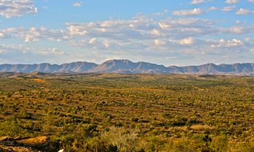
Exploring Namibia’s Central Region The central region of Namibia is the starting point for most trips organized around the country, since the capital Windhoek with its international airport, Hosea Kutako, lies in the centre of the region. A well-maintained road structure and many guest farms, B&Bs and lodges make the Central region an ideal stopover for visitors en route to the Etosha Pan in the North, the Fish River Canyon in the South, or the West Coast. Vegetation is typically bushy (thornbush savanna) with lots of grasslands, bushy shrubs, camelthorn trees and many hills and mountains which makes for interesting scenery. About 300 bird species have been recorded in this vegetation zone, from ground feeders like Red-billed Francolin, and helmeted Guineafowl to those that look for food in the canopies of trees like the beautiful Pied Barbet. Game is abundant also in this area with many species of antelope (especially kudu) being a common sight. Most game farms, however, hold a wide variety of game ranging from leopard, rhino and lion right down to the smaller game like springbok and open vehicle game viewing is a daily activity on offer at all farms. Places of Interest in the Central Region: Windhoek, the heart of Namibia! The capital of Windhoek lies in the heart of Namibia. It possesses a unique charm due to the harmonious blend of African and European cultures. Despite being one of the smallest of the African capitals, it has over the years developed into a thriving, efficient city with a superb infrastructure which has gained popularity as a safe tourism, business and conference destination. With two airports, Hosea Kutako International Airport, which lies about 40km East of the capital and Eros Airport, situated on its outskirts, international and domestic/regional flights are well catered for. Since Namibia’s independence in 1990, tourism has boomed and Windhoek offers many world-class restaurants, coffee shops, guest houses, B&B and hotels to choose from. Visit the local markets in the North-Western suburbs of Windhoek to gain insight into the true Namibian community way of life, visit the many monuments and historical buildings in and around the capital and browse at leisure through local craft markets and the many curio shops on Independence Avenue. For advice on outings and day tours, visit the Windhoek Tourism Info Office in Post Street Mall, situated right opposite the Zoo Park, in the heart of the city. Healthcare facilities are top class with two state hospitals and three private clinics (Rhino Park, Roman Catholic and Medi Clinic) offering well-equipped facilities and well-qualified medical practitioners. Intensive Care units and 24-hour medical emergency services are always on call. Car hire companies and tour operators are manifold in the capital. Air Namibia is the national airline of the country with many travel agents and offices around town. Most guesthouses and B&Bs offer booking advice and services regarding transport, trips and tours around the country. The Namibian post and telecommunications network is well established and cell phone companies offer the usual packages and satellite reception of good international standard. Internet cafés have sprung up like mushrooms – so there’s no need to lose touch with your loved one’s when travelling in Namibia. Banks are well represented in the capital and all offer efficient foreign exchange facilities. Autobanks also offer Saswitch transactions and are usually well-serviced and maintained. Shopping for mementoes or stocking up on your travelling kit is a worthwhile pursuit when in Windhoek and coffee shops and restaurants offer scrumptious meals and the best coffees since your last Italian cappuccino.
Read More
Namibia has been called many names – Thirstland Wilderness, The Land God Made in Anger and Land of Contrasts, to name a few. It is indeed a land of contrasts, with much of it wedged between two enormous deserts, the Kalahari in the east and the Namib in the west, and its north-eastern extremity, the Caprivi Strip, penetrating the tropical riverine swamplands and floodplains of Angola, Zambia, Zimbabwe and Botswana. With its surface area of 824 268 square kilometres, Namibia is a vast country, even by African standards. Southern Namibia is characterised by extensive grassy plains punctuated with the occasional windmill, flocks of karakul sheep and the prehistoric-looking quiver tree. Its major features are Sossusvlei in the Namib-Naukluft Park, the majestic Fish River Canyon further south, the desert horses of Garub, the quaint harbour town of Lüderitz and the former diamond settlement, Kolmanskop. The central region is dominated by Namibia’s capital, Windhoek, with the rolling hills of the Khomas Hochland to the west. On the Namib coast are many points of interest for the visitor, including Namibia’s top seaside resort, Swakopmund, the legendary Sandwich Harbour, and the Cape Cross Seal Reserve and its affiliated lichen fields. Further north is the mysterious Skeleton Coast with its hinterland, Damaraland, a region rich in geological phenomena, and the remote expanses of Kaokoland, the land of the ochre people and desert-adapted elephant and rhino. It is in this north-western section of the country that many of the top tourist destinations are found: Twyfelfontein with its rock engravings, the monumental Brandberg famous for the White Lady rock painting and Epupa Falls on the Kunene River. Namibia’s top tourism drawcard, however, is the Etosha National Park, situated in central northern Namibia, where large herds of game are seen against the ghostly white expanses of the Etosha Pan. To the east are the water-rich areas of Kavango and Caprivi, a bird-watcher’s paradise and a place for complete peace and relaxation. Supported by a good road network and an interesting mix of accommodation establishments ranging from luxury lodges and hotels to basic community campsites. Namibia has something to offer every tourist, whether a nature lover, specialist tourist, an adventure traveller, a four-wheel drive enthusiast or a person interested in local people and their different customs and traditions.
Read More