

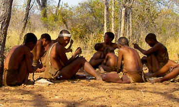
The Bushman / San Descended from the Khoisan peoples, the Bushmen are the earliest known inhabitants of Namibia. These hunter-gatherers roamed the vast plains of Southern Africa for thousands of years before migrants armed with weapons and searching for new land drove them further and further east into the Kalahari and Namib deserts, where some still practise their traditional, nomadic lifestyle. Today there are approximately 35 000 San people living in Namibia, most of them on farms in the eastern parts of the country or in remote communal areas in the Otjozondjupa and Omusati regions in north-eastern and north-eastern Namibia. The Bushmen’s former habitation in many parts of the country is evidenced by the rich wealth of rock art found in caves and overhangs in mountainous and hilly areas. Two well-known examples are Twyfelfontein with its rock engravings, which was awarded World Heritage status by the World Heritage Committee (UNESCO) during 2007, and the Brandberg, famous for the rock painting known as the White Lady. Twyfelfontein has in excess of 2 000 rock engravings and the Brandberg a recorded number of over 8 000. A high degree of mysticism is embodied in the San culture, which has endured over thousands of years due to oral traditions. These wanderers of the arid plains are renowned as storytellers, expressing themselves eloquently in prose, music, mimicry and dance. Moth cocoons filled with seeds or stones attached around their ankles provide rhythm when they dance. One of their instruments consists of a hunter’s bow that has been strung with animal hair and equipped with a sound box in the shape of a hollowed-out melon or, especially nowadays, a tin can. Like most semi-nomadic people around the world, the Bushmen adorn themselves with beads made from ostrich eggshells and glass. Fashioned into necklaces, bracelets and anklets, these items are worn by both men and women and are often exchanged as gifts. Archaeological evidence suggests that the techniques used today are similar to those used centuries ago. Ostrich eggshells are broken into smaller pieces and then the edges are chipped to shape them into round, flat beads. A hand bow is used to drill the central hole, and the different pieces are assembled, traditionally with raw sinew, nowadays with commercial beading thread. Production of such items is often shared. Beads, for instance, are carved by the men and threaded by the women. Most of the materials used for body adornments are collected in the bush, including seeds, porcupine quills, roots and berries. Functional items such as bags used for collecting wild fruit and berries and storing tobacco and matches are made from softened antelope skins. The Bushmen are divided into three groups – the Hai||omn who inhabit the northern districts of Otavi, Tsumeb and Grootfontein; the !Kung and Ju//Huansi in Bushmanland (Otjozondjupa Region) and the Gobabis district and the Khoé or Mbarakwengo in West Caprivi. The area that comprises the Etosha National Park today was once the ancestral home of the Hai||omn Bushmen. Their existence first gained international publicity in 1925 following the Denver Expedition, whose members claimed they had ‘found the Missing Link’ in the Hai||omn people. In the 1950s the Hai||omn in Etosha were instructed by the South African administration to leave the park, as they supposedly represented a threat to the wildlife. When Namibia became independent in 1990 it was generally thought that this hailed a new era for the Bushmen in the country. The new Namibian regime recognised that as a group the Bushmen were by far the country’s most disadvantaged people. However, by and large their situation has remained unchanged. In 2007, the year the centennial of the Etosha National Park was celebrated, the evacuation of the Hai||omn from their ancestral lands was once again brought to the attention of the general public. In the words of Reinhard Friederich, a farmer who grew up in northern Namibia and was exposed to Bushmen from an early age, “While the proclamation of Etosha as a national park has left not only the Namibian nation but also tourists worldwide a precious jewel, the Hai||omn people need to be recognised and appreciated for the sacrific.
Read More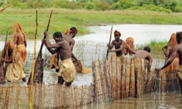
The Caprivians The Caprivi Strip, as it is historically known, was named after Count Leo von Caprivi, the German negotiator at the Berlin Conference held towards the end of the 1800s between Germany and other colonial administrators. The Caprivi has a chequered history of administrative changes. Before 1992 the water-rich pan-handle in Namibia’s far north-east was administered separately by three countries – South Africa, Botswana and the former South West Africa – while prior to independence the Caprivi Region was isolated from the rest of Namibia, as it was used strategically by the South African Defence force in its fight against Swapo guerrillas. It remained a centre of conflict throughout the struggle for independence achieved in 1990, after which there was further political strife when a group of secessionists staged a political uprising in 1998–1999. The Caprivians share their language with the Lozi of Barotseland, the remnants of the Kololo Kingdom, established by Chief Sebetwane of the Bafokeng, who crossed the Zambezi River in 1838. Although Lozi is Caprivi’s current official language, it is the mother tongue of only a few people living in eastern Caprivi. Today the six main ethnic groups living in the region – the Masubia, Mbukushu, Mbalangwe, Mafwe, Totela and Mayeyi – speak three other distinct Bantu languages and many different dialects. The largest groups are the Masubia and Mafwe, while a small group of Mbukushu and some San communities live in the more arid western Caprivi, a long, narrow strip of land that is primarily a nature reserve, with the Trans-Caprivi Highway running through it. About 86 000 people live in Eastern Caprivi, which borders on Angola, Zambia, Zimbabwe and Botswana and has the bustling town of Katima Mulilo as its capital. Caprivi’s just over 20 000 square kilometres of land fall either under state or communal administration. The state-controlled areas consist primarily of game reserves and national parks, state forest and agricultural projects administered by different ministries and the National Development Corporation (NDC). Subsistence farming is practised within the communal areas, which are also put to commercial uses via hunting concessions and tourist lodges and camps. Most Caprivians make their living on the banks of the Zambezi, Kwando, Linyanti and Chobe rivers. When the Zambezi and Chobe come down in flood, more than half of Eastern Caprivi becomes inundated and wooden mekoro, dug-out canoes, become a common means of transport. Being surrounded by perennial rivers, freshwater fish are an important resource in Caprivi, providing food and income for many locals and recreational angling for visitors. Agriculture is, however, of greater importance than fishing in terms of economic and livelihood activities. Stock farming is dominated by cattle, primarily the indigenous Sanga breed, an animal steeped in social, religious, economic and mythical significance. Cattle are highly prized for their value as tangible resources, and especially for their social value of giving herd owners security, rights to land and status. Goats and poultry, on the other hand, are valued only in terms of food and as a source of income. Crops are primarily the staple mahangu (pearl millet). A growing source of income for Caprivian women is pottery and basket-making, ancient crafts that have been revived in recent years to provide families with an income.
Read More